In 2003 the historian Naomi Oreskes, working with Homer Le Grand, published a book with the title Plate tectonics: an Insider’s History of the Modern Theory of the Earth, but she herself was not one of the insiders concerned; she is far too young for that. She did, however, manage to persuade a number of the pioneers of the plate tectonic revolution to provide their own memoirs of that period, and produced a book that is a fantastic historical source, though necessarily limited to those geologists and geophysicists who agreed to contribute. Some obvious names are missing; Bill Menard, for instance, is not there, probably because he wrote an entire book on the subject instead He called it The Ocean of Truth.
What might also be considered missing from Oreskes book are the memories of the geologists and geophysicists who just happened to be around at the time, the foot soldiers rather than the leaders of the revolution. Historians today tend to value the opinions of the peasants and labourers as much as those of the kings and nobility, and that must surely apply to their geological equivalents as well. With that in mind, I somewhat hesitantly offer my own recollections of that time.
I went to university in 1958, choosing to study physics rather than geology but with the clear intention of becoming a geophysicist, and after graduating, and knowing almost nothing about the Earth Sciences, I started looking around for places to learn. I began, and in fact ended, my search with just the two institutions most prominent in geophysics at the time.; Cambridge’s Earth Science outpost in the almost bucolic surroundings of Madingley Rise and Imperial College’s Royal School of Mines (RSM). If I had gone to Cambridge, I would have preceded Fred Vine by a year. Would I have spotted what he spotted? I rather doubt it, but whether I would have even had the opportunity I will never know, because Applied Geophysics, as defined and taught at the RSM with a promise of abundant fieldwork, seemed far more exciting than academic research. I withdrew my application to Cambridge, enrolled in RSMs’ diploma course, and for ten months in 1961-62 was force-fed the basics of geology. Our textbook was Arthur Holmes’ Principles of Physical Geology, which devoted an entire 25-page chapter to continental drift, so I was immediately exposed to such ideas, but it would be an exaggeration to say that they formed any part of our course. It was the nuts and bolts of field mapping, stratigraphy and mineralogy that concerned us, and if I had any thoughts about drift, it was to wonder how it was that so many geologists rejected the arguments for it while being quite happy to accept the possibility of hundreds of kilometres of horizontal displacement along strike-slip faults.
The teaching we had at the RSM was first class and has stood me in good stead for the rest of my professional life. It was delivered by inspiring lecturers like ’Prof’ (never John) Bruckshaw and Den Taylor-Smith, but there was one staff member who I don’t think I even saw, and that was Ron Mason. Rumour had it that he was doing something very clever with Scripps in California, but no one seemed to be quite sure what that was. It was, in fact, at about that time that the two seminal Mason–Raff papers publicising the magnetic ‘stripes’ in the ocean crust off California were appearing in print; Ron’s earlier attempt at doing this, in 1958 and using only the results from the first survey, seems to have attracted no attention whatsoever at the RSM, although in California they were creating something of a stir.
So it was that in November 1962, blissfully ignorant of any research being done at the institution I had just left but armed with its diploma, I boarded a Comet for the day-long flight to Australia to join the Geophysical Branch of the BMR, the federal government’s Bureau of Mineral Resources, where I was promptly assigned to the aeromagnetic section. Not my first choice, but I was lucky enough to take part in the testing and the first experimental surveys of a proton magnetometer in Australia. Carried out at low level in a single-engined Cessna, this should have been exciting enough for anyone but I still hankered after experience in a wider range of geophysical methods and eventually obtained a transfer to the engineering section, which used multiple methods in surveys for underground water and on dam sites. Almost the last piece of work I did for ‘Airborne’, in late 1965, was to prepare the specifications for a high altitude survey across Tasmania, extending out over ocean crust to both east and west. I wasn’t sure why this was wanted, but I did as I was told. Looking back on it now, I suspect that my seniors in the section, with the Vine-Matthews paper already two years in print, had some notion that interesting results were being obtained in magnetic surveys over ocean crust and thought that Australia should be in on the act, but had only the vaguest idea of why. And no more did I.
Engineering section was indeed different, and lived up to expectation, and it did involve me, very peripherally, in a research project. Academic geophysicists in Australia had discovered that its navy was in the habit of disposing of its unwanted and outdated explosives by taking them out to a suitable point offshore on HMAS Kembla and dumping them over the side. It seemed to them that they could be put to better use if they were actually detonated in a way coordinated with onshore seismic recording stations, to measure the depth of the upper mantle over several hundred kilometres of refraction profile. That was the origin of the Bass Upper Mantle Project (PROJECT BUMP). I and a colleague were doing some work in Tasmania that involved seismic recording equipment, and ignoring the fact that this was designed for shallow refraction surveys, we became one of the recording stations. We duly recorded the arrivals and handed the records over to the academics and that, as far as we were concerned, was the end of it. It might also have been my sole contact with geophysics research, had it not been for the BMR’s penchant for making use of people who happened to be in an area at the right time, rather than sending a special team from the appropriate section out to do what was required. For me, that had important consequences. It changed my life.
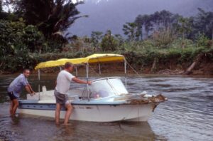
Figure 1. One of the jet-boats used for survey of the Papuan Ultramafic Belt, after failing to take a bend in the river it was following downstream.
By 1966, even geologists whose work was focussed on field surveys and data gathering were vaguely aware of something called plate tectonics, and that continental drift, while still controversial, was no longer anathema. This was causing little surprise in the southern hemisphere, where it never had been anathema. The faunal similarities in places as widely separated as New Zealand, Australia, South Africa and South America were just too strong for former contiguity not to be assumed, although some wild and woolly alternative solutions to drift were being considered. In particular Sam Carey, professor of geology at the University of Tasmania, was a great publicist for an expanding Earth, and embraced sea-floor spreading enthusiastically when it came along but rejected subduction. It was, however, subduction, and its inverse, obduction, that eventually brought me into academia.
The start of 1966 saw me still in the Engineering Section and destined for work on a dam site near Rabaul in Papua New Guinea. The BMR’s Geological Branch, however, had an ongoing Eastern Papua Project (EPP) in which they had thought a gravity survey would make a useful contribution, and had borrowed a gravity meter with that in mind. Unfortunately (but fortunately for me), the geologist entrusted with it managed to tangle the spring system (easily done with a Worden gravity meter) and the readings he obtained were useless. Never again, the Geophysical Branch vowed, would a geologist be entrusted with one of their instruments. However, they generously offered the services of a geophysicist who was going to be in Rabaul; on his way home, they said, he could make measurements in conjunction with the geological mapping programme on and around the Papuan Ultramafic Belt, one of the world’s largest ophiolite bodies. The survey would use jet boats and small helicopters to get around.
At that time ophiolites were a hot topic. With plate tectonics becoming established, the question being posed was how they fitted into that scenario. Today the answer seems obvious, but then less so. For those who argued that they were simply oceanic crust ramped in some mysterious way on to continents they were too thick, and for those who argued that they were forearc crust they were too thin. How, it was being asked, could subduction zones, still suspect concepts in some quarters, produce sheets of rock with thicknesses of only a few kilometres covering area of hundreds of square kilometres? I can’t claim my gravity surveys contributed much, or anything, to solving this problem, but they did throw up some new ones, some of which I still find baffling. The most significant contribution of the study, however, was to provide an answer to a problem that I had not even known existed.
That, however, is running a little ahead of the story. The very limited gravity surveys done in 1966 were thought by the Eastern Papua team to be useful and that led to a plan to cover the whole of the project area, which was mostly accomplished in 1967. By early 1968 a total of some 1100 gravity stations had been occupied, but by then a chance visit to Canberra by Prof Bruckshaw had led to my being accepted as a PhD student back at the RSM, provided that the BMR could be persuaded to release the gravity data. They could, and in mid-1968 I headed back to London. Sadly, however, the Prof. had been taken ill by the time I arrived, and he died a few months later. I found myself being supervised by the staff member I had not previously met. Ron Mason.
From my point of view, Ron was an ideal supervisor. Having discovered what I was doing, he commented only that New Guinea was a risky place to be doing research, because any ideas I had might be proved wrong in a few years’ time’, and then left me pretty much to my own devices. As far as Plate Tectonics was concerned, I learned far more from Tony Richardson, the department’s palaeomagnetism specialist, and one of our conversations gives a vivid picture of the state of affairs in Earth theory at the time. Used as I had been in Airborne to looking at line by line correlations of magnetic profiles, I was distinctly unimpressed by those from the oceanic surveys that were increasingly being reported in the literature, and asked him how secure he thought the evidence for magnetic striping to be. His reply was that he thought, despite all the ‘noise’ on the profiles, that oceanic linear magnetic anomalies were pretty well established but that the evidence for subduction was pretty dodgy. ‘Dodgy’, of course, was an opinion still then widely held of the data from his own speciality. It had, unfortunately, been discovered that self-reversal of the direction of the remanent magnetic field could take place in rock samples, and that was being used to cast doubt on the whole concept of Earth-field reversal. At RSM, however, Plate Tectonics was the accepted paradigm, and that was the basis on which I viewed my own data.
The gravity surveys as extended had covered not only the Papuan Peninsula to its easternmost tip but also the two chains of islands stretching out to the east. The area between them seemed likely to be oceanic, but no-one, and certainly not me, was giving it much thought. I was, however, as a PhD student still learning about gravity and geology (does one ever stop?), anxious to estimate the effect the low-density sea-water columns might have on measurements on the islands (something, incidentally that I would not dream of doing now). The problem there was that the bathymetric data I had, mainly extracted from Admiralty charts, were totally inadequate for the job. Without much hope, I wrote to the Australian navy’s hydrographers to see if they had anything better, and astonishingly they had. They had just completed a detailed survey of a large part of the area and, even more astonishingly, they were prepared to let me have the data and even publish it on a small-scale map.
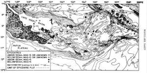
I dutifully set about contouring and digitising the data at the rather coarse spacing needed for the gravity corrections, and whilst doing so noticed, to my surprise, that there was a linear trough running north to south in an area where every other feature was, and was expected to be, elongated east to west. In 1969, with plate tectonics well established, the solution was obvious. This had to be an oceanic fracture zone, offsetting an E-W spreading axis. That led to further thoughts about the basin, which is roughly triangular, and to plotting the seismicity (Figure 2), which led to the conclusion that here was a very young small ocean basin that at its western end was propagating into, and splitting, the continental crust of New Guina, while at its eastern end it was disappearing down the Solomons subduction zone, active spreading ridge and all, and giving the volcanoes in that section some quite unusual characteristics. That made one chapter in my thesis, and I managed to get it published in JGR. Notably, the paper made no mention of the gravity field, the thing that had started the journey down that particular rabbit hole.
Since that time the Woodlark Basin has become a happy hunting ground for oceanic cruises and some deep sea drilling. First in the field, in 1973, were Woods Hole, who, rather peevishly, I thought, complained that I had failed to determine the rate and history of spreading, and they were followed by many others, as the list of references in a recent publication attests. The basin may well be the most intensively investigated piece of ocean crust on the planet and that would, I am sure, eventually have happened without my intervention. All I did was notice what was going on a little before anyone else, but that is, however, an interesting, and very far from unique, example of the way that, in science, we sometimes, blunder on a solution whilst thinking of something else entirely, and before we even realised there was a problem.