Back in the mid-1960s, I shared a helicopter with Hugh Davies and together we tried to understand the geology and geophysics of eastern Papua in general and the Papuan Ultramafic Bely (PUB) in particular. Plate tectonics was still in its infancy and controversial, but the origin of the shallow rises in the Tasman Sea that culminated in New Zealand as strips of Australia peeled away like layers on an onion, was already pretty obvious. Inevitably, we speculated on possible links between the PUB and the ultramafic nappes of New Caledonia.
There is an awful lot of sea in between. The easternmost outcrops of ultramafic rocks in PNG are in the southwest corner of Normanby Island, and they are more than a thousand kilometres from the northern tip of New Caledonia. Moreover, even in the 1960s enough was known about the seafloor between those places to suggest that just taking the straight-line (or great circle) distance was too simplistic. For those outcrops to be so far apart, if they had once been close together, very large amounts of translation and rotation would have been needed. The problem was not significantly reduced even when it was proposed, following the drilling of ODP Site 1117, that the Moresby Seamount, off the northeastern tip of PNG’s Normanby Island ( and therefore quite a long way from Port Moresby) might be ophiolitic.
In 2022, however, Anders McCarthy and his co-workers published a paper with the title “The Louisiade ophiolite: a missing link in the western Pacific”, in which they suggested that the gap between the two ophiolites might be somewhat smaller than Hugh and I had supposed. As a result of dredging along the northern flank of a subsea feature known as the Louisiade Plateau by the Australian research vessel Investigator during Cruise IN2019_V04, and of interpretation of the extreme south-west end of the seismic reflection profile obtained along Line 1 of the joint Japanese-American cruise EW 95-11 in the Solomon Islands (Figure 1), they concluded that a fragment of an eastern extension of the PUB had been thrust over the plateau from the north. If that is the case, then the idea of a former continuity between the ophiolite belts in Papua New Guinea and New Caledonia becomes a little more plausible.
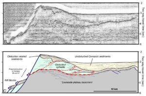
Figure 1. Time migrated seismic section and interpretation of the extreme south-west end of EW95-11, Line 1, from McCarthy et al, 2023. Location indicated by solid yellow line on Figure 2. North-east is on the left. Note that line is highly oblique to the structures in this area.
The focus of the McCarthy et al. paper, which appeared in Terra Nova, was petrological, and the bathymetric maps that accompanied it were either very general, covering the whole area from New Guinea to New Caledonia in just one half of a page-width, or very detailed indeed, and none of them showed the location of the seismic line. Fortunately, these days it is usually possible to make one’s own maps, and some of the most useful ones when dealing with areas that are largely covered by sea are maps of free-air gravity. These are dominated by the effects of bathymetric features with wavelengths of a few tens of kilometres, and are presentations of the primary data on which large parts of today’s conventional bathymetric maps of much of the globe are based. The bathymetry derived in this way can be downloaded from the same website as the free-air gravity and, in a operation that is somewhat suspect because they are partly derived from the free-air gravity, can be combined with the free-air gravity to produce maps of Bouguer gravity.
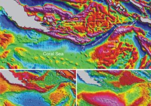
Figure 2. Top: Free-air gravity map for the area from eastern Papua to the Louisiade Plateau. The yellow line on the free-air map marks the location of EW95-11, Line 1 (solid where related to the image in Figure 1) and the white circles mark the dredge sites at which ultramafic rocks were recovered. Lines 2a and 2b from the paper ‘Itina Trough and Other SW Pacific Examples of Rifting Across Former Subduction/Collision Zones’. Bottom left: bathymetric map. Bottom right: Bouguer gravity map. All maps based on data from University of California at Sant Cruz grids, downloaded from website https://topex.ucsd.edu/cgi-bin/get_data.cgi.
It is immediately obvious from the maps in Figure 2 that there are two distinct parts to the Lousiade Plateau, and that they are so different that it is actually not helpful to regard them as forming a single feature. The Bouguer gravity patterns in particular are strikingly different, and were it not for the presence of a deep trough generally known as the Pocklington Trough, the northern part might have been regarded simply as a continuation of the ridge capped by the islands of the Louisiade Archipelago. It is therefore important to understand when and how this trough developed.and it is convenient to discuss the area in terms of North and South Louisiade Plateaus (N.L.P. and S.L.P. respectively).
Happily, there is another recent paper, this one by Brian Taylor, that helps It reinforces the concept of different North and South Louisiade plateaus by dividing the Pocklington Trough into two parts and christening the part to the north and northwest of the N.L.P. the Itina Trough. The distinction is based on bathymetric profiles along the lines labelled 2a and 2b on the free-air gravity map, and the most cursory inspection of that map indicates that these profiles must indeed be very different. Profile 2a images an asymmetric feature widely identified as an inactive or remnant trench, whereas 2b crosses an almost symmetrical graben, interpreted by Taylor as an extensional feature associated with the initial opening of the Woodlark Basin. The question, of course, then arises as to where the boundary between the two should be placed, and free-air gravity suggests that it should be only few kilometres west of Profile 2a.
There is yet another reason for suggesting that the two parts of the Louisiade Plateau deserve different names. At the AGU 2022 Fall meeting Lara Kalnins and her co-workers presented a paper in which they argued, on the basis of samples dredged from the Louisiade Plateau on the same Investigator cruise as McCarthy and his co-workers, that the plateau is actually a volcanic construct, an oceanic Large Igneous Province (LIP) with some continental influence. Presumably these samples came from dredge sites different from those reported on by McCarthy et al., who specifically cast doubt on the LIP concept. We cannot, however be certain of this, because we have at the moment only the meeting abstract to go on.
Should, then, workers in this area be following Brian Taylor’s lead, and be giving the two parts of the Louisiade Plateau different names?