In Gaimard’s account of the visit of the Uranie to Mauritius he listed the heights, and in some cases the latitudes, of more than two dozen prominent topographic features. At no other port of call did he do this, and there is no suggestion that the measurements he recorded had been made by anyone on the Uranie. It is not difficult to discover the primary source of the information, but the story is itself an interesting one. It links his captain, Louis de Freycinet, to a member of the island’s mixed-race community and to a now almost forgotten French cleric who died more than fifty years before the Uranie arrived off Port Louis.
Nicolas Louis de Lacaille, usually known simply as the Abbé Lacaille, is now chiefly remembered for the work he did at the Cape of Good Hope in the period 1751-1753. Brian Warner described how he was sent there by the Académie des Sciences to map the constellations visible in the skies of the southern hemisphere. Having completed that work in August 1752, and finding himself at a loose end because no ships would be leaving the Cape for Europe until December at the earliest, he decided to fill in the time by measuring the distance on the ground corresponding to a degree of latitude. It was work that he had already been engaged in within France itself, and only a few years previously French expeditions to Lapland and Ecuador using this method had shown that the Earth was, as predicted by Isaac Newton, not a perfect sphere but flattened towards the poles. The question that had not been answered was whether it was a true ellipsoid of revolution or consisted of two hemispheres of slightly different shape. The result Lacaille obtained by measuring 84.3 miles (1.2 degrees) along an arc of meridian suggested that the two were in fact different, and when, in 1816, Louis de Freycinet was writing the proposal that culminated in the voyage of the Uranie, the desirability of confirming that result was one of the principal arguments he presented. The test he proposed would use pendulums to measure gravity at widely separated points, as an alternative to the laborious and time-consuming business of measuring distances on the ground.
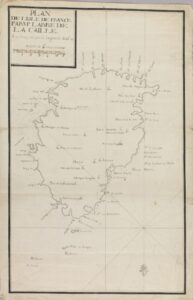
Lacaille’s first map of Mauritius. South is at the top. Longitudes are referred to a prime meridian through the Paris observatory. Note that the names of coastal features would appear right way up if the map was always viewed with the coast along which the ship was travelling to the left. Map owned and digital image placed on line by the Huntington Library, California.
Whether Lacaille’s work at the Cape was widely known in French scientific circles more than sixty years after it was carried out is unknowable, but de Freycinet certainly had reason to know of him, and even to use some of his survey results. These were not, however, results from Africa. Instead of being allowed to return directly to France in 1753, Lacaille was told to go to Mauritius and Réunion to measure longitude on both islands. It was boring work, but he carried it out conscientiously and probably did considerably more than was expected of him. He painstakingly measured the entire coastline of Mauritius and estimated the circumference, and he measured the heights above sea level of more than eighty prominent features (all to the nearest toise, a unit equal to six pieds di Roi and so to 6.4 feet or 1.949 metres), as well as a considerable number of latitudes and longitudes. The results were published in the Mémoires de l’Académie in 1754.
When de Freycinet took the Uranie to Mauritius, which he knew as the Isle de France, he was going to to a place that he had been to before. Twice. He had been there on the outward journey,of the Baudin expedition, during a visit notablefor the number of the scientists assigned to the expedition who declined to go any further, On the return journey, although still only a Lieutenant de Frégate, he arrived on the island as the captain of the schooner Casuarina, purchased by Baudin in Sydney for inshore mapping. After reaching Mauritius the Casuarina was sold, and after some time on the island, during which Baudin died, de Freycinet returned to France on the Géographe. During his stay he acquired enough information on the geography of the island to make his own map, and in 1811 he published an account of how he went about it..The Abbé ‘s work was fundamental to what he did, but there was one other person on whom he relied. This was the mixed-race scientist and cartographer Lislet Geoffroy, who had just been appointed Captain of Engineering on the island.
It is at this point that the story links to Gaimard’s diary, because Lislet Geoffroy was a man about whom he had much to say, although nothing directly related to either science or cartography. What he wrote about was the man’s moral character and his actions in relation to one of the scientists of the Baudin expedition who had settled on the island. The latter had established a pharmacy in Port Louis but had lost everything in the great fire of 1816, and following that disaster Lislet-Geoffroy had offered him a house and had ‘opened his purse’ to him, allowing him to build his business anew. “May the name of M. Lislet Geoffrey”, wrote Gaimard, “be known amongst all men of honour”. Even though he did not mention the fact, this must surely have been the man from whom he obtained his topographic information, just as de Freycinet had done fifteen years earlier. As far as distances were concerned, this may have simply meant access to a copy of Lacaille’s Journal historique du voyage fait au cap de Bonne-Espérance, because even some of the wording is replicated. On page 217 Lacaille wrote:
Selon mon calcul, fondé sur les mesures géométriques que j’ai faites dans cette isle, son contour est de 90668 toises. Je l’ai déterminé par la somme des côtes d’un poligone circonscrit à cette isle, de façon que le terrein qui se trouvoit hors de ce poligone fût, à très-peu de chose près, compensé par l’étendue des petites bayes ou anses qui rentroient en dedans de ce même poligone. Son plus grand diametre est à peu près, Nord & Sud, de 3 1890 toises, & sa plus grande de largeur prise à peu près Est & Ouest, de 22124 toises. Sa figure est ovale, ayant le sommet du Nord plus alongé, & celui du Sud plus applati. Sa surface est de 432680 arpens à 100 perches de 20 pieds de longueur : c’est l’aire du poligone dont je viens de parler.
…… while Gaimard wrote, on page 229:
L’Ile de France, d’après les calculs de Mr L’abbé de Lacaille, offre une surface de quatre cent trente mille six cent quatre vingts arpens, à cent perches de vingt pieds de longueur.
…… and on page 260 :
La longueur de l’île du nord au sud, prise depuis le Cap Malheureux jusqu’à la pointe du bras de mer des citronniers, est de 31,900 toises. La plus grande largeur, prise depuis la pointe du Diable jusqu’à l’extrémité la plus septentrionale de la plaine aux sables, est de 22,130 toises. Le contour total de l’île est de 90,630 toises ou trente cinq lieues marines et demie ou environ quarante cinq lieues parisiennes. La surface totale de l’île est de 480,744,062 toises carrées ou 432,680 arpens.
The bold lettering highlights the exact repetition of a phrase. The values in the two documents do not quite correspond, but that is quite possibly due to Gaimard being very typically slapdash where numbers were concerned. In the second quote from his diary the surface area of the island is given exactly as Lacaille wrote it.
As far as elevations were concerned, there were only two differences between those given by Gaimard for 26 points on Mauritius and the outlying islands and those given by de Freycinet as being obtained directly from LaCaille. The height of the Morne Brabant is given by Gaimard as 286 toises rather than 283 toises, and the height of the Montagne du Savanne is given a 655 toises rather than 355. 655 toise is considerably higher than the highest point on the island and both discrepancies can be fairly attributed to copying errors on Gaimard’s part. Interestingly, the heights given for the Pouce, Pieter Both and the Corps due Garde, mountains, for which Gaimard gave the heights twice, differ by less than one toise from the currently accepted values, which is impressive testimony to the accuracy to which Lacaille worked. He was less successful with the fourth member of that group, the Trois Mamelles, where he overestimated the height by some 40 metres.
Two small mysteries remain.
Why, one might ask, did Gaimard list only latitudes and not longitudes? In all probability, because he was copying from a document held by Lislet Geoffroy that was written at a stage when latitudes had been calculated but the more difficult longitudes had not.
And why did he bother to set out all this information in a notebook destined to be handed to de Freycinet at the end of the voyage, when de Freycinet had himself published the same information in 1811? The answer must surely be that Gaimard was not aware of the fact.
Poor Gaimard. All that effort for nothing.