During my three stints at the Royal School of Mines, South Kensington (as a diploma-course student, a PhD student and a lecturer), we did our best to ignore the fact that we were part of Imperial College. The RSM was the thing. That attitude may have been mirrored by IC, or at least by one of its librarians, because a friend of mine, foraging one day in a skip in the loading bays at the back of the building, caught sight of a very battered volume, on the cover of which were stamped the words “Imperial Geophysical Experimental Survey”. Thinking I might be interested (he had been searching the pile of discards for books on proper geology), he sent it over to me. A new world, or rather, a somewhat old world, opened up.
The full title of the book was The Principles and Practice of Geophysical Prospecting – being the report of the Imperial Geophysical Experimental Survey, and it was, so the title page claimed,, edited by A. B. Broughton Edge, B.Sc,. A.R.S.M., F.G.S., M.Inst.M.M. and T. H. Laby, M.A., Sc.D., F.Inst.P., F.R.S.
Back in those days, every physicist used Kaye and Laby’s Tables of Physical and Chemical Constants and Some Mathematical Functions, first published in 1911 and last printed in 1996, after which it went on-line. It was mildly interesting to discover that Laby had been involved in geophysics, was an Australian and had been Professor of Natural Philosophy at the University of Melbourne, but there were other names on a later page that were, to me, much more significant. Listed as ‘Attached to the Survey’ was ‘J.M Bruckshaw, of the Department of Scientific and Industrial Research, London’. By the time I knew him, he was Professor of Geophysics at the RSM and he taught me on the diploma course. Six years later, had he not died a few months after accepting me again as a student, he would have been my Ph.D. supervisor. No doubt it was thanks to him that the volume my friend had found was in the library in the first place. To be fair to the librarians, it had been a second copy, and was in very bad shape.
The Prof was not, however, the only familiar name on that list. In tandem with him as ‘Attached’ was ‘J. M. Rayner, of the New South Wales Department of Mines’, and moving to the lower echelons, the Electrical Section had a field assistant called R. F. Thyer, while designated as a Temporary Assistant was one N.H Fisher.
By the time I joined Australia’s Bureau of Mineral Resources (the BMR) in 1962, Jack Rayner was its director. He was appointed to the position in 1958, having been Deputy Director since 1952, and he remained there until 1969, when he was succeeded by Norm Fisher. Norm held that post until1974, having been Chief Geologist (or, as some tin-eared bureaucrat rechristened the position in the 1960s, Assistant Director – Geology) since the BMR’s foundation in 1946. And, from 1952 until 1974,when Norm was appointed Chief Director (Operations), the Chief Geophysicist was Bob Thyer. Bob succeeded him. Truly, the IGES was a development ground not only for geophysical instrumentation in Australia, but for geophysicists.
How had it come about?
Remarkably, but an indication of just how much has changed in the relationship between Australia and the UK in the last hundred years, it was all organised from London.
“ The preparatory work in connection with the Survey was carried out at Australia House, London, in February 1928, in close consultation with the Empire Marketing Board, the Department of Scientific and Industrial Research, and the Geological Survey of Great Britain. Instructions were also received from the Geophysical Executive Committee that had recently been formed in Melbourne for the purpose of controlling the activities of the Survey as soon as it commenced operations in Australia. Throughout this preliminary work the advice and guidance of Mr F. L. McDougall, C.M.G., and his staff at Australia House, was indispensable, and to their knowledge of Australian conditions the avoidance of many mistakes is to be attributed. “
It was certainly a good idea to involve at least some people with knowledge of Australia, but it is all rather reminiscent of a rather more famous Englishman who, some ten years later, was to refer dismissively to a conflict in “a far away country, between people of whom we know nothing”. Fortunately, the outcomes of the IGES for Australia were rather better than Neville Chamberlain’s intervention was for Czechoslovakia, and a considerable amount was learned in a rather short time. Especially, one supposes, by Messrrs Rayner, Thyer and Fisher. What that amount might have included was well summarised by Table 1 of the Introduction.
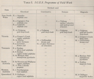
Table 1. The IGES programme of work.
Of all the methods used, it was the magnetics that came closest to what I remembered from my own early days. 1928 would not have seemed that remote to me in 1963, or even now, and it was a bit of a shock to realise that the book was describing work begun almost a hundred years ago. It, truly, was history – perhaps I am too.
Be that as it may, the approach to ground magnetic survey, a method described as being ‘comparative simple’ since ‘full details of the procedure are readily available from published works’, was not so very different from what I did when I did the grounf follow up of the1964 airborne survey at Renison Bell in Tasmania, my first as party chief. The ‘vertical variometers of the Schmidt pattern b, which had been purchased by the Survey‘, and which ‘could be used efficiently by any of the technically trained staff’ were not so very different from the ABEM vertical field instrument I used then.
Gravity survey, however, was vastly different. The Worden and LaCoste gravity meters were no more than gleams in the eyes of their inventors, and their one or two-minute reading times, when they did eventually appear on the scene, bore no resemblance to the hours it took to get one reliable set of readings from the Oertling Torsion Balance and all the accessory equipment purchased for the IGES. It was not an easy instrument to use, but fortunately its designated operator…..
‘was able to study the Oertling Torsion Balance and the general field procedure of gravimetric surveying under the guidance of the Geological Survey which, at that time, had a gravimetric field party operating in Scotland’ [and he] ‘was also able to spend some time in Cumberland with Messrs Shaw and Lancaster-Jones of the Science Museum, London, who were carrying out a gravimetric survey there over iron-ore deposits’.
Or perhaps not so fortunate, for him at least, because the expertise he acquired would qualify him to spend hours on end in the closed cylindrical observation box that shielded the instrument from wind and the ever-present Australian bush flies, but not from the climate of Cooper’s Creek.
At least, however, there was expertise in gravity available, and instruments to go with it. It came as something of a surprise to learn that electrical surveys were not similarly favoured and that :
‘the necessary equipment, contrary to the cases of the gravimetric and magnetic methods, could not be purchased in the open market from instrument manufacturers.
That was not the only problem.
Moreover, the methods themselves were described at the planning stage as as ” having been treated by the companies employing them as jealously-guarded secret trade processes, and it must be agreed that there are grounds for this indictment. Although numerous papers on electrical prospecting methods have appeared during the past few years it is most unusual to find information in any of them which can be of the slightest assistance in the design of instruments, or in the use of the methods in the field; in fact, the sincerity of some of these publications is open to considerable doubt. As a result of this difficulty in obtaining information about instruments and procedure many of the electrical investigations carried out by the Survey were necessarily of an experimental character.”
Less surprisingly, there was little experience that could be called upon when seismic methods were being considered, So little, indeed, that the method itself was not included in the early plans,
“since neither experienced operators nor the necessary equipment could be secured. This branch of geophysical work was entirely in the hands of certain geophysical companies, and not until nearly a year later was it considered possible for the Survey to carry out such investigations. They were then included in the programme of the Survey upon the recommendation of the Australian branch of the Institute of Physics, which drew attention to the fact that, following on their war experiences of seismic methods, the late Professor J. A. Pollock, F.R.S., and Major E. H. Booth of Sydney University had, for some years, been carrying out experiments by an electrical recording system, which is very similar to that now being employed in geophysical investigations. Major Booth was available and consented to act as consultant to the Survey in this branch, and on his recommendations the necessary microphones and electromagnetic recording apparatus were obtained. At the same time a standard seismograph of the mechanically recording type was purchased. This instrument had recently been designed by Professor Schweydar of Potsdam and, although a single recording unit only was used by the Survey, it proved of considerable value for purposes of comparison. The field party, which was placed under the charge of Mr R. L. Aston, M.Sc., B.E., conducted field tests over two of the most suitable areas that could be found in New South Wales, and a large amount of valuable information was obtained. A more extensive programme of seismic work was not possible in view of the late date at which the investigations were commenced. Owing to the paucity of published information of a practical character regarding the application of seismic methods to geological problems, the Survey’s experience of instruments, methods, and field procedure had to be gained entirely ab initio.”
With so much yet to be learned about the methods to be used, it might have been thought over-ambitious for the experiments ’to target specific mineral fields, in the hope of making economic discoveries’. But no, as Table I suggests, discoveries were very much hoped for. There was, however, a caveat. As a final comment in the Introduction, its author concluded that
“The possibility should also be borne in mind that, in some cases, the failure to locate mineral might well have been due to the fact that no mineral was present in the ground that was examined”.
A sensible warning. So sensible, in fact, that one wonders that it needed to be made at all!