I have got into the habit of writing three blogs a month. There is always one that, like this one, is about some topic in the Earth Sciences, usually with a historical aspect, and another is in some way related, sometimes quite distantly, to the 1817-1820 scientific voyage of the French corvette Uranie. I first became interested in this voyage because part of the science was that the measurement of gravity by pendulum was used to answer some of the outstanding questions regarding the shape of the Earth. This means that there can, almost inevitably, be some cross-over between the two series, and I was reminded of this quite forcefully when doing a last read-through, before it was sent to the copy editor, of the annotated translation of the diary of Joseph-Paul Gaimard, one of the surgeon/naturalists on the Uranie that Sylvie Brassard of the University of Weern Australia and I are preparing for the Hakluyt Society. In the instructions Gaimard received before he left Toulon, which he copied into the diary, there is a long section on how to do geology. Despite being written in 1817, it could very usefully be given as a guide to the first-year geology students in our universities. Amongst other things, it has some very nice sketches (never underestimate the importance of field sketches), and some wise words on the importance of context.
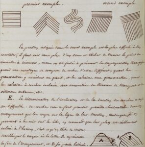
A part of Gaimard’s original diary, showing the two sketches intended as instruction for trainee field geologists.
The wise words regarding the upper of the two illustrations on the page reproduced above, were :
When observing the relative positions of stratal layers, they should be examined closely to determine whether they are superimposed in parallel and whether they are continuous or broken or deformed; if one set of strata rests on another with a different attitude, the relationship is termed transgressive.
The situation illustrated in the second example is the most difficult to describe well; it has to be viewed from more than one direction and every effort should be made to find a place where the contact is exposed. It is, however, justifiable to assume transgressive superposition when a mountain is made up of rocks of different types, e.g. if greywackes overlie granite, or limestones overlie greywackes, or when dipping limestones are overlain by transported material and Tertiary sediments, etc.
As far as the second sketch is concerned, the advice is more specific:
The determination of the inclinations and strike directions of layers also has its problems. Strata seen end-on can appear horizontal in an escarpment that cuts them parallel to the strike direction, even if they would be seen to be inclined to the horizontal if viewed from the side. The sketch is intended to demonstrate this, where ‘A’ shows the face of the escarpment, and ‘B’ the side view.
Who amongst us has not on at least one occasion been misled, hopefully only temporarily, into supposing that a layered sequence is dipping only shallowly or not at all, because that is how it appeared at first sight.
On this particular read through, however, it was one other paragraph that struck me most forcefully.
As for detached blocks, they should not be entirely ignored, especially if a probable origin can be assigned to them; even sand and pebbles should be collected from the valley floors, from the plains and from along the river banks, sometimes as indicators of the composition of the surrounding high ground, sometimes as evidence of transport by water.
It struck a chord because it took me back to a time when I was working with a team from Operation Wallacea that was studying an area of almost pristine rainforest, and I had with me a volunteer who had just recently graduated with a degree in geology from one of the UK’s leading universities. At one point I stopped to examine some of the boulders scattered along a dry river bed. My companion was horrified, pointing out, quite correctly, that these were not rocks ‘in situ’, and she seemed quite reluctant to accept my argument that despite that, we knew something about where they had come from (upstream) and that letting the rocks come to you was surely a more gentlemanly way of doing geology than struggling through the forest to find them. It seemed that in three university years she had never been introduced to the concept of float mapping.
Going back still further in time, I wondered how the geological maps of Papua New Guinea, made in the mid-1960s to mid-1970s and still largely valid today, would ever have been produced without that concept. Rocks in PNG were encountered in three forms: (a) those obviously in situ, (b) those that might be, but it was impossible to tell, and (c) ‘float’ – which could on occasion be the size of a family car.
If my geological colleagues had ignored (b) and (c), the job would never have got done.
There is, of course, a bit more to float mapping than simply searching at just one point along the course of a river to see what rocks it has brought down. In the PNG mapping programme the rivers and their banks were mapped methodically, since that was where most of the genuine outcrops were to be found, but the rocks they were bringing down were never ignored. If one rock type disappeared from the selection, that was a very fair indication that a geological boundary had been passed. Float mapping is both an art and a science, and it needs to be taught.