On the 12th of March 1819 the Uranie passed close to the island known to those onboard as Bartolomé, but to the people who actually lived there as Pulusuk. The following day, the corvette was in sight of the island of Alet on the Poluwat atoll and of Tamatam, Fanadik and Pollap on the Pollap atoll, just 50 km to the NNE. They did not stop at any of these places, but the Carolinians ‘was’ were easily able to keep up with them while mutually satisfactory trading was carried on.
Given that this was the nearest that Gaimard came to actually visiting the Carolinians on their home islands, he wrote a surprising amount about them. A more prolonged contact was with the Carolinians from Satuwal, who visited Guam on their way to their colony on Saipan, and who took Arago, Bérard and Gaudichaud (but not Gaimard) with them as far as Tinian. There was also a considerable amount of information on the islands and the islanders in the archives in the governor’s palace, which was translated by Gabert and copied by Gaimard into his diary, and more was learned from Don Luis de Torres, who had actually been to some of the islands. One result of all this is that the Gaimard’s diary contains not only two vocabularies of Carolinian languages, but several listings of the islands. These latter are not, however, easy to follow, because many of the names used are not only different from those used today, but different in different lists, and the list provided by Don Luis had its own idiosyncracies.
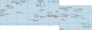
Figure 1. Don Luis de Torres names (shown in red) for the Caroline islands, based on the information given on pp.412 and 413 of Gaimard’s diary Mogmog is the island on the Ulithi atoll closest to Guam, so it is not surprising to see its name assigned to the whole atoll. The name Mugrak is nowhere else applied to Lamotrek, but given its position in the listing, it seems that this must be the island known to Don Luis by that name. He seems to have been unaware of the existence of Chuuk, or of any high islands in the Carolines. Note the distances involved in travelling between islands the Carolinians would regard as neighbours. Base maps are of Yap state, uploaded by Aoteroa and of Chuuk state, uploaded by Tyk, both apparently originally on Polish Wikipedia,
One atoll that appears repeatedly in the list is Woleai, known to Gaimard as Olié or Guilay and notable for the presence on its reef of around twenty habitable islands. Mysteriously, some of those that appear on old lists, including on a Spanish map of 1886, seem to have disappeared, leaving no trace of their existence on modern air-photos or satellite imagery. Gaimard provided no fewer than four separate listings, on pages 408, 411, 411.412 and 453 of his diary.
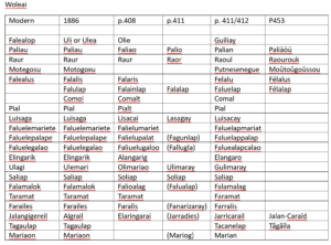
Figure 2. Alternative names for the islands on tthe Woleai atoll. Page numbers are for entries in Gaimard’s diary.
The most informative of Gaimard’s listings of the wider Carolines, because it provides directions as well as just names, begins on p.411 of his diary and continues on to 412. It states that:
The islands known as the Carolines comprise: the small Farruelap archipelago,] consisting of three islands forming a triangle, situated at 8°30’N, 144°30’ longitude east of London, the Guliay[archipelago, situated [412] at 7°N, 144°E, …… To the north-west of Guiliay lies Fais; to the southwest of Fais are eight islands called Mugmug; to the east of Mugmug lies Japa and south of Japa, Nolog; to the southwest of Nolog, Pannog (the three last named, together with Mugmug are also known under the name of Palaos), to the south of Guliay lies Haurupig; to the south-east of Guliay are Ytelug, Elad, Mugrak, Satahual and Poloat; south of Poloat lies Sog; to the east of Sog lies Rug; to the north-east of Poloat lies Tametam, and to the north-east of the latter is Pollap; to the north-west of Pollap lies Olol, to the north-east of Olol lies Magor to the south-east of Magor lies Pizaras, in the same wind direction lie Fallao, Namuhil and Felalu; to the east of Magor lies Marilo; to the north-east of Marilo lies Ruao and to the south-east of Ruao is Lemo
This is the source of the names shown in red on Figure 2, but the islands after the words ‘same wind direction’ raise all sorts of questions. Only Marilo can be positively identified, and there are no islands to the north-east of it. Nor are there any islands that can be positively identified with Fallao, Namuhil and Felal. The Carolines still present unanswered problems, and none of these problems are soved by anything else that Gaimard had to offer. The list he provided on p. 411 seems potentially an exception, because it gives the populations of some of the islands, according to one of the chieftains.:
Capiapo said that he thought that there were two thousand people on Lamursec, the seat of the king, while on Elato, ruled by Cautao, there were twelve hundred. On Ulor there were eight hundred and eighty, Tuquas, one hundred, Falati, a hundred and thirty Puc, one hundred and seventy, Gulimarao, two hundred and twenty five, Ulatan, just two, who harvested coconuts, Car, fifteen, Falipti, twenty-five, Ulimaray, more than five hundred, Falalap, two hundred and fifty, Soliap, seventy, Palio, one hundred and twenty five, Raor, one hundred and ten, Mariog, ninety, Fagunlap, more than eighty, Fallugla, fifty, Lasagay, twenty four, Falualap, thirty-six, Jarradies, fifty, Fanarizaray, thirty-two and that the others were uninhabited.
Which would be very usefule, were it not for the fact that very few of these islands can be identified. However, things get worse, and the final blow is delivered on p.453, which lists more names than any other, but few that are comprehensible.
Sāōūk, Souk, or Poulou-Souk; Tamatam; Pouellap; Roug; Houlahoul; Pissérarr; Félaluk; Poulouat; Jalé; Satahouan; Pik; Piguélo; Faïāōū; Olimérāōū; Lamourtrōkĕ; Pouk; Féléït; Oūrālu or Ouralouk; Tahouas or Talouas; Elatt; Sélat; Ouletann; Caré; Nemoï; Cahutac or Tahutac; Falĕpi; Ifelouk or Iféluk; Séraïlap; Jatté; Séralap or Félalap; Païāōū or Paliāōū; Raourouk; Sériap; Féralūōūs or Félalus; Moŭtoŭgoŭssou; Tăgăïla; Jalan-Caraïd; Nisségaï; Éramlap or Élanélap; Éroupèk or Aouroupik; Faïs; Mogoumog; Essouroug or Iassōro; Nāmo; Sōūnĕ or Sōnĕ; Sagalaï; Lāmo; Sérahoul; Iappé; Moloug; Cahénānĕ or Cahènĕ-hānĕ; Palloul or Palleu; Péliou or Péliliou; Récapessan; Aïoupoucoul; Récamaï; Arapokel or Arapoket; Érougoulmalapaior Rougoumalipaï; Argoūnĕ, Argol or Argoul; Crélaōū; Nargoumaï; Atalendran or Atalènĕ-hānĕ; Néï-houan; Aran-harell or Aran-harett; Ïaourou; Rékériou; Aléhal; Sigal; Soutămènĕ; Eicānĕ; Ahoucaho; Pul; Mérier; Soun-roūnĕ; Catougoupouï; Fahoupouï; Loūme; Polap; Pélépiel; Moutougouléï; Cassiulon; Lull; Luc; Lamolĕpi; Opānĕ; Poual; Éal; Alamaraa.
Not many of these islands can be easily identified, and the effort needed to identify the others is scarcely worthwhile, since there is no accompanying information about any of them.