In 1810, the cartographer Aaron Arrowsmith was appointed Hydrographer to the Prince of Wales, and by natural progression, in 1820 and at the ripe old age of 70, to King George IV. It was a recognition of the sterling work he had done over the previous decades, beginning with his 1790 map of the world. That map, and the many later maps produced over the years by him and by the family business he founded, document the steady increase in European knowledge of the rest of the world in the late 18th century and the first half of the 19th. But how good were his early maps at depicting the then little known region of Micronesia? It is a question easily answered, because a high resolution digital image of his 1798 map of the Pacific Ocean can be downloaded from the website of the US Library of Congress.
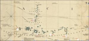
Figure 1. Extract from the Arrowsmith 1790 Map of the World. White circle overlays show important islands or island groups in their true sizes and positions in relation to the latitude/longitude grid.
Figure 1 shows the sea area of the Carolines, going as far as Palau in the west and Guam in the north, and superimposed on which are white circles within which are plotted the largest islands (Yap, Guam, Chuuk, Ponape and Kosrae), and also the much smaller but historically important islands of the Elato and Lamotrek atolls. That the positions assigned to these islands are incorrect is no surprise, but what is surprising is the very large deviations from true size. A navigator passing through this area at the start of the 19th century might have expected to see himself surrounded by islands on all sides, but in fact he would be fortunate if he saw even one or two.
If that was a disppointment, he might perhaps have blamed it on Jacques Nicolas Bellin (1703-1772), a French hydrographer and geographer who was also a member of the Royal Society in London. Having been appointed chief cartographer to the French navy at the age of 18, in 1741 he became the first Ingénieur hydrographe de la Marine (cartographer to the French Hydrographical Office). Inevitably, his maps were based on information obtained, usually in map form, from sources of varying reliability, and his Histoire Générale des Voyages, ou nouvelle collection de toutes les relations de voyages par mer et par terre, published in 1761, included not only, as Plate 18 in the Supplement to Tome X, a Nouvelle Carte des Iles Carolines which, for all its imperfections, is clearly recognizable as a map of the Carolines, but also, as Plate 17, a Carte des Nouvelles Philippines. The latter, while showing many islands with names corresponding to those of islands in the Carolines, scatters them about the western Pacific in a manner that it would be kind to call fictional. Fortunately, in compiling his own map Arrowsmith ignored Plate 17 and relied on Plate 18 when he came to map the Carolines, but It was by doing this that he overestimated the sizes of the islands by such enormous amounts. Was this, however, also perhaps deliberate? Most of these islands are associated with much more extensive reef complexes, and a navigator approaching any of them incautiously might easily find himself wrecked. Perhaps Arrowsmith felt it best to err on the side of caution.
There are, of course, also many problem in the Carolines with island names. As pointed out by Riesenberg, amongst many others, some names have been duplicated, having been heard differently by different explorers, many have been misapplied, and in some cases a single island was known under very different names in different European languages before all but one was discarded. This occurred wholesale in the early 19th century, when the majority of the names given by Russian explorers such as Krusenstern (1803–6), Kotzebue (1815–18), Bellingshausen (1819–21) and Lütke (1826-9) to islands and island groups in the Pacific had generally only temporary currency.
One island, however, stands out as causing more problems than any of the others. Hogoleu or Torres Island was shown by Bellin as the largest of all the Caroline islands and was accepted as such by Arrowsmith, who placed it between about 158⁰ and 159⁰E longitude, and 9⁰ and 10⁰N latitude. This is too high a latitude for any of the Caroline Islands, but the longitude is about right for Pohnpei. However, in the 1820s, when the Hogeleu name was still in use, the island was reported by Isidore Duperrey (in hisVoyage autour de Monde, Hydrographie et Physique, p96) as being visible from mid-day positions at 7⁰26’N, 150⁰ 10’E on the 17th of June 1824 and 7⁰ 41’N, 149⁰ 23’E on the 18th. His longitudes should, presumably, have the longitude difference of 2⁰ 22’ between London and Paris added to make them compatible with the Arrowsmith map, but that places the island at the longitude, and the latitude, of the Chuuk lagoon, also the site of high islands. It seems that at the turn of the 18th century Chuuk and Pohnpei were being confused.
Duperrey deserves the credit for being the first European to report on Kosrae, which he called Oualau, establishing a temporary observatory there at 5⁰ 21’ 25”N, 160⁰ 49’ 42” E (of Paris}, but it seems he managed to sail from Kosrae to Chuuk without sighting the 782m peak of Pohnpei. It should have been visible at distances of up to 100 km.