Every so often I trawl the internet in search of gravity information on East and Central Europe, with a particular focus on the northern end of the Adriatic. The starting point for any such search has been the map compiled under the aegis of the CELEBRATION 2000 project which was published in 2006. A quick glance at this map reveals a very considerable variability in coverage between countries. Notably, contouring for Russia, Ukraine, Romania and former Yugoslavia was clearly based on a very sparse station distribution, which is frustrating, because it was well known that extensive and quite detailed surveys were completed under the pre-1990 regimes. Some of these data sets may have been lost, but most are preserved somewhere, It has just been a matter of discovering where.
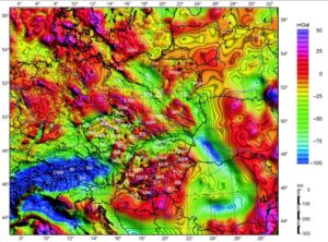
Figure 1. The CELEBRATION 2000 Bouguer gravity map (Bielik et al, 2006)
A collaboration more recent than CELEBRATION 2000 has been the AlpArray Gravity Research Group (AAGRG), part of the European AlpArray program, and this has unearthed some of the missing information. While much of their data came from the countries that had participated in CELEBRATION 2000, the new republics of Croatia and Slovenia were important additions. The station distribution map that accompanies the report on the project that was published in 2021 showed quite dense coverage in these countries. The situation in the whole of former Yugoslavia was summarised as follows:
3.3 Digitization and reprocessing of the CBA map of the former SFR Yugoslavia
Although the peripheral southeastern part of the new Bouguer gravity map is not covered by terrestrial data which were available to the project, this area was filled by the digitization of the CBA [complete, i.e, terrainn corrected, Bouguer gravity] map of the former SFR Yugoslavia at a scale of 1:500 000 (Bilibajkič et al., 1979). The CBA map (with a correction density of 2670 kg m−3) was published in 1972 and covers the whole area of the former SFR Yugoslavia. Its northern part was converted into an electronic form in the diploma thesis of Grand (2019). For the needs of the AlpArray project, a map was used especially for the territory of Serbia and Bosnia and Herzegovina. The gravity data of Slovenia and Croatia were also originally part of the Yugoslavian gravity map (refer to Appendix B – Croatia). In contrast to the digitization for the AAGRG described here, the Slovenian and Croatian database contains new data.
The reprocessing included the identification and correction of individual steps in the frame of CBA calculations to ensure a processing status which complies with that of the recalculated anomaly of the new AlpArray map. Specifically, normal gravity was corrected for the difference between the IGF 1967 and the Somigliana/GRS80 equations. Then the simple free-air correction was replaced by a more accurate approach, and the sphericity of the Earth was taken into account. However, this was neglected in cases when simple planar Bouguer corrections in the original data were used. For the last two corrections, the approximate heights at the digitization points generated from the model MERIT (multi-error-removed improved-terrain) were used. Finally, atmospheric correction was calculated, which was not considered in the original CBA. These reprocessing steps remained problematic as the uniform procedure of their calculation was not used for the original CBA map and the original values were not published. Therefore, given that MC and BC could not be recalculated and replaced by new values, we must expect more significant errors in the transformed CBA. Figure 8 shows a comparison of transformed CBA map with a map constructed from available data within the project for Croatia. Fortunately, the differences between the maps are not significantly large, the standard deviation of differences is about 1.8 mGal with a low systematic difference (the mean value of the differences is less than 0.5 mGal). We therefore assume that the replaced anomaly in the southeastern part of the map (Serbia, Bosnia and Herzegovina) is of similar quality than the main part.
For Croatia, this summary was supported by an illustration comparing the AlpArray map with a digitised version of the map of former SFR Yugoslavia. The differences are small, but significant.
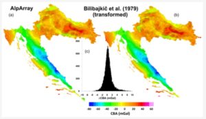
Figure 2. Differences between the latest gravity map of Croatia and a digitised version of the 1:500 000 scale Bouguer gravity map of SFR Yugoslavia published in Belgrade by the Federal Geological Institute Belgrade (Bilibajkič, P., Mladenovič, M., Mujagič, S., and Rimac, I., 1979).
Were this map the only one of Croatia available, the peculiar shape of the country would have made it a frustrating one to work with. However, and also in 2021, gravity maps of Croatia were published by Varga and Stipčević that made full use of the data from the surrounding countries. Their maps show, and use, an abundance of data from much of Serbia and almost the whole of Bosnia-Hercegovina.
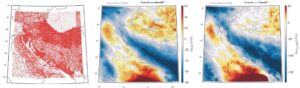
Figure 3. Gravity maps of Croatia, from Varga and Stipčević (2021). Left: gravity data distribution. Centre: Terrain-corrected Bouguer gravity. Right: Airy-Heiskanen topographic-istostatic gravity.
Remarkably, the isostatic correction seems to have made very little difference, even though this is the area in which the Moho was first defined by Andrija Mohorovičić, showing the Airy-Heiskanen isostatic compensation mechanism to be the right one, at least for continental areas. The isostatic gravity minimum associated with the Dinaric Alps is more extensive and considerably deeper than the corresponding Bouguer minimum. Only in the Sava Plain in the north-east does the correction seem to have had its expected results.
Food for much thought there.