Volcanoes that look like volcanoes fascinate. They are nearly always impressive, and are important as reminders that what has happened catastrophically in the past could very easily happen also in the future. Inevitably, they are young; there are not many places on the Earth’s surface where what is essentially a pile of ash will preserve its shape for very long against the combined assaults of wind and rain. Most are still classified as potentially active, and most have been well studied, simply for that reason. Almost all appear in the catalogue of the Smithsonian Institution Global Volcanism Program, but one at least does not.
The tiny island of Tikopia, with an area of only 5 sq km, is one of the most remote inhabited places on the planet. Its people are Polynesians, a western outlier on the edge, or beyond the edge, of the ‘Polynesian Triangle’ that occupies so much of the southern Pacific, and if it appears at all in the literature of science and history it is because of that fact and because of its role in the discovery of the lost remnants of the LaPerouse expedition. If the internet is any guide, there have been just two geological studies. In his 1978 paper on the volcanic Eastern Outer Islands of the Solomons, Geraint Hughes wrote:
Tikopia is a small island of definite Pleistocene age dated as 80,000 years B.P. by FRYER (1974)*. It is an extinct volcano, the central part of which has been enlarged by central collapse to form a pit crater whose south side has been breached. A slightly saline crater lake now occupies the centre of the island. The volcano is composite, with lava dominant over volcaniclastic material. The lavas are oligoclase augite andesites, but labradoritic olivine clasts dominate the agglomerates.
Which summarises pretty much all that the paper by Patricia Fryer, a.k.a. (in marine geological circles) the ‘Queen of the Marianas’, had to say about the island.
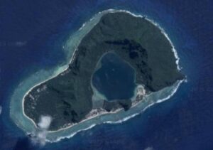
Figure 1. Tikopia. Google Earth image
But why is Tikopia there?
It sits close to the middle of what appears to be a small triangular oceanic plate in the northwest corner of the Fiji Plateau (Figure 2). To the north the plate is bounded by the Vitiaz Trench, to the west by the Vanuatu Trench and to the south by a poorly-defined feature known, according to your preferred interpretation, either as the Hazel Holme Fracture Zone (HHFZ) or the Hazel Holme – South Pandora Slow Spreading Centre. The volcanic islands to the east (Tinakula, Nendo, Utuoia, and Vanikolo, of which only Tinakula is active) can be assigned to the Vanuatu Arc with a fair degree of confidence, but the proposal by Geraint Hughes of a Duff-Anuta-Fatuitsalka arc associated with a westerly-dipping Vitiaz subduction zone active during the Middle Miocene to late Pliocene is less plausible. In 1978, when his paper was published, the bathymetry of the area was almost unknown, but modern maps, where bathymetry is gravitationally controlled via satellite-radar show the Duff Islands on a completely different feature from Anuta and Fatutaka. If anything, the maps suggest that it is Tikopia that should be linked to the Duff Islands, but not only is such a link to some extent contradicted by the isolation suggested by the magnetic patterns (see Figure 10 of Charvis & Pelletier; 1989) but it makes an association of the Duff Islands with the Vitiaz Trench even less likely.
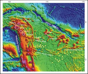
Figure 2. NW North Fiji Basin, bathymetry. Open white circles are used to emphasise the locations of islands too small to be obvious at this scale. Yellow circles indicate the locations of ultra-deep (550km+) earthquakes occurring between 1964 and 1969, as plotted by Wan-Ping and Brudzinski (2001)
In the final analysis, questions regarding the origin of Tikopia cannot be separated from those concerning the origin of the possible small plate in which it is located, and according to an Abstract in Geophysical Research Letters, that has had a very complex history:
Four successive spreading phases are distinguished in the northwestern part of the North Fiji Basin. After an initial NE-SW opening, a N-S spreading phase took place, up to the northwesternmost tip of the basin, along the South Pandora, Tikopia and 9°30 Ridges. The N-S spreading phase in the northern North Fiji Basin was followed by an E-W opening phase along the central North Fiji Basin axis. A triple junction was probably active during an intermediate stage between the two phases. E-W spreading underwent a reorganisation that induced the functioning of the 16°40′S triple junction and the development of the E-W trending Hazel Holme Extensional Zone from the active central spreading axis to the southern tip of the New Hebrides Back-Arc Troughs. Active extension also occurs along the E-W Santa Cruz Trough which crosscuts the arc platform at the northern end of the N-S trending Back-Arc Troughs. The existence of the Back-Arc Troughs is mainly due to the construction of the 400 km-long volcanic Duff Ridge which trapped a piece of the old North Fiji Basin oceanic crust.
This at least provides a plausible setting for the Tikopia volcano, at the intersection of the Tikopia Ridge and a presumed transform offset linking to the 9°30 Ridge, but the evidence for this exact sequence of spreading events is hard to find. The most detailed study so far of the HHFZ was published in 2003 by Erwan Grel, Bernard Pelletier and Yves Lagabrielle, but the north-western corner of the North Fiji Basin is also remarkable for the presence of clusters of earthquakes at depths in excess of 550 km which have no plausible association with any existing subduction system and which have been interpreted as indicators of the presence of a detached and sunken lithospheric slab (Figure 2). The main cluster is somewhat to the south of Tikopia but does at least suggest the presence in the area of anomalies in the mantle that might be linked to this isolated volcano.
The earthquakes themselves could possibly be responses to pressure changes at depth which are expressed at the surface by the HHFZ, but this feature is still itself a conundrum. Its surface expression is reportedly that of a series of small fault-bounded basins produced by N-S extension, whereas fault-plane solutions for shallow earthquake show almost pure transcurrent motion, all taking place within the context of what Keith Marten has labelled as ‘double-saloon-door tectonics’. This concept is itself questionable, and it may be more useful to see the North Fiji Basin as an orocline, similar to the Banda Sea and the Pannonian Basin, where collision of thick crust with a subduction zone (the Ontong Java Plateay with the Vitiz system) has led to the development of an arcuate orogen with such a high degree of curvature that the opposing end-sections are almost parallel.
Whatever mechanisms are involved, there can be no doubt that without their operation there would be no Tikopia..
Which would be a great pity.
*FRYER, P., Petrology of some volcanic rocks from the Northern Fiji Plateau, Geol.Soc.Am. Bull.,85,1717-1720,1974