Once again, I am indebted to Felipe Santos. Had it not been for a Bouguer gravity map he sent me, I might never have even been aware of the existence of the plateau in the South Atlantic that is known to Brazilians as the Elevação do Rio Grande and more clumsily in the English-speaking world as the Rio Grande Rise Massif. The clumsiness arises from the fact that, by the time the marine geological community became interested in the area, there was already a feature named the Rio Grande Rise (RGR), of which the massif forms just one, although perhaps the most important, part.

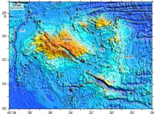
Figure 1. Bathymetry of the Rio Grande Rise Massif (RGRM). Extract from Figure 2 of the 2021 paper by Sager et al., Late Cretaceous Ridge Reorganization, Microplate Formation, and the Evolution of the Rio Grande Rise – Walvis Ridge Hot Spot Twins, South Atlantic Ocean, Other bathymetric features identified by initials; CB, Centaurus Basin; CM, Corvus Massif; ERGR, East Rio Grande Rise; HM: Hydra Massif; LM: Libra Massif; VT, Vema Trough. The prominent NW-SE rift system that cuts through both the RGRM and the Libra Massif is the Cruzeiro do Sul rift.
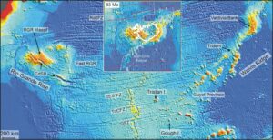
As far as the Rio Grande Rise as a whole is concerned, there is general agreement as to its origin. It is now uncontroversially accepted as being a hot-spot trail, conjugate to the Walvis Ridge that extends from the eastern flank of the Mid Atlantic Ridge (MAR) to the African continental shelf. Volcanic structures generated by that hot spot or mantle plume have been transported from the MAR by sea floor spreading to form the trails, while southwards directed relative movement of the hot spot with respect to the overlying crust has given them their distinctive alignments at roughly forty-five degrees to the ridge (Figure 2).
Given this plate-tectonic setting, it is almost Inevitable that the major massifs in each trail (the Rio Grande Rise Massif and the Valdivia Bank) have been interpreted as the two halves of an originally continuous hot-spot-related plateau formed on the MAR. Interest has been sparked recently by emerging evidence for past subaerial exposure, hyped up, in a headline that went well beyond the available evidence, by a claim that ‘The Rio Grande Rise was once a giant mineral-rich tropical island’. A more measured assessment provided by Srivastava et al. in 2023 does provide evidence for subaerial exposure of parts of the RGR massif at some point in its history, and the recovery of granitoids by dredging (which could, however, be dropstones) has led to consideration of a possible former role as a part of a microcontinental fragment. The fact that both it and the Valdivia Bank are relatively close to their respective continental margins gives some support to this idea.

Figure 2. Extract from Figure 1 of Sager et al. (2021) showing the conjugate Walvis Ridge and Rio Grande Rise, with the coastline of Brazil appearing in the top left-hand corner. The inset, an extract from Figure 15 of the same publication, shows the interpreted mid-Atlantic plateau at an early stage in the separation of the RGRM from the Valdivia Bank. It has been modified by the superposition of the coastline of Iceland at the same scale.
If, then, the RGRM was once an island, or part of an island, what sort of an island? If the present is the key to the past, is there any feature in today’s geology that can provide any sort of an analogue?
In the reference from which Figures 1 and 2 have been extracted, the authors note that the conjugate Rio Grande Rise and Walvis Ridge ‘are considered to be similar to the classic Hawaiian-Emperor hot spot seamount chain and to represent motion of the two plates over a single mantle hot spot, once located at the Mid-Atlantic Ridge (MAR)’ but later also note that they are ‘more complex than the simple Hawaiian-Emperor and Louisville seamount trails’, neither of which is, in any case, associated with a spreading ridge. Nor is there any significant subsidence ‘moat’ surrounding either massif, as there is around the major Hawaiian Islands, and the subsidence of a former RGRM island, if indeed it ever was an island, has to be attributed to the general thermal subsidence that takes place as newly created ocean crust moves off-ridge. There is, however, a much better possible analogue than Hawaii for a possible sub-aerial presence, and it is much closer to home. As the inset to Figure 2 shows, the subaerial part of the combined Rio Grande Massif and Valdivia Bank could well have been of a similar size to Iceland when located, as Iceland is now, on the crest of the MAR.
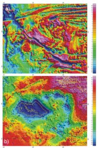
As far as is known, Iceland is an entirely oceanic product (although see Foulger et al. 2020). Is there any information of which use has not yet been made that might throw more light upon it as a possible RGR Massif analogue? There does seem to be; the Sandwell-Smith free-air gravity values and the derived bathymetry can be used to create a map of its Bouguer gravity. Rather obviously, there are some caveats to be observed in using the Bouguer values, since there is a element of circularity in their derivation; the bathymetry is itself partly based on the free air gravity. However, the process is controlled by conventional bathymetric data, which in this area is likely to be of adequate quality. Maps of free-air and Bouguer gravity, prepared using Sandwell and Smith values and Geosoft programs are shown in Figure 3.

Figure 3. (a) Free-air graviity of the Rio Grande Rise Massif and surrounding area. (b) Bouguer gravity map of the same area. See text for data source.
The free-air map (Figure 3a) is a striking one, even though the actual range of values is small, suggesting something close to full regional isostatic compensation. To an even greater extent than the bathymetric map of Figure 1, it is full of feature. The sea-floor spreading patterns in the ‘normal’ ocean in the north and northeast and the Cruzeiro do Sul Rift are as visible as they are on the bathymetry (itself Sandwell-Smith derived) of Figure 1, and perhaps even more so, and the less obvious complexities of some of the structures in other regions are emphasised because free-air gravity will, to some extent, still see a sea-floor low even when sediment filled. Clastic sediments, although much denser than sea-water, are still normally less dense than the basement rocks on which they are deposited.
On a regional scale, and especially offshore, Bouguer gravity tends to be dominated by crustal thickness, and the map shown as Figure 3b is at first sight much simpler than the free-air map. All values are positive, as is to be expected offshore, but deep relative lows correlate with areas where thick crust is to be expected. The main low, which correlates with the Rio Grande Rise Massif, has a minimum value of less than +100 mGal and a central area enclosed by the +200 mGal contour, suggesting a depth the Moho of a little less than 20 km. It is hard to see any significant difference between the RGRM Bouguer gravity and Iceland’s Bouguer gravity as it is discussed in a 2002 paper by Kaban et al, with the title ‘Nature of the crust-mantle transition zone and the thermal state of the upper mantle beneath Iceland from gravity modelling’, but in that paper the low values are interpreted thermally. Given the very different thermal regimes now operating in the two areas, it might be expected that the gravity fields would be more different than they actually are, but In view of the uncertainties surrounding the deep structures in both areas, as pinpointed in the papers referenced, it is surely worth considering whether either one has something to tell us about the other.
But that is a subject for much more than a short blog
