In the late 1990s the European Science Foundation, taking advantage of the new possibilities for scientific interchange and fieldwork in a Europe no longer divided by an Iron Curtain, sponsored an international programme known as PANCARDI to provide an umbrella under which geologists and geophysicists from the countries containing parts of the Carpathian and Dinaric orogens and the Pannonian Basin could come together to exchange information and reach a better understanding of the evolution through time of that very complex region. The project was extremely successful, although the enthusiasm for it inevitably varied from country to country and, in common with all such projects and programs, it was time limited. Ten years later, working on a commercial project involving data from Poland, Romania and the Czech and Slovak republics, I had no sense of there being strong continuing cooperation between those four countries which, together with Hungary, had been key contributors to PANCARDI. Sadly also, the impression I had when attending the 15th Emile Argand Conference on Alpine Geological Studies in Ljubljana in September 2022 was that, at least as far as international cooperation was concerned, the PANCARDI region had become something of a backwater and that attention had shifted back to the heartland of geology in the Alps sensu stricto. The 2020 special issue of Solid Earth entitled New insights into the tectonic evolution of the Alps and the adjacent orogens included articles on the Bohemian massif, the Ligurian Basin and the extreme northern Dinarides where they impinge on the Alps but nothing on the Carpathians. Notably also, the temporary recording stations of the massive and enormously impressive ALPARRAY seismic tomographic program have so far been confined to the Alps.
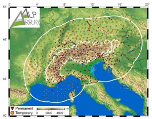
Locations of permanent and remporary seismic recording stations of the ALPARRAY project.
Studies of the gravity field in the Carpathian region have also been fragmented, and there seem to have been few attempts at continuing cross-border collaboration. In 2017 a new gravity map of Slovakia was released based on data from 319,915 discrete points, an extraordinary number for a relatively small country, and a similarly detailed map of Hungary was released in 2010, but the two cannot be combined without recourse to the original data because of the different colour scales. It is, perhaps, symptomatic of the present-day situation that the report on the work done in Slovakia was published in the Slovak journal Contributions to Geophysics and Geodesy, which has very limited circulation outside its own country, while the work done in Hungary was not only reported in the similarly little known journal Magyar Geofizika but in Hungarian, a language regarded as challenging by most non-native speakers.
In Poland and Romania gravity data are scattered amongst a number of institutions and much is held confidential because of its commercial significance, and in my experience (admittedly more than ten years out of date) much has been processed in ways that differ from the international norms, while in Ukraine and the successor states to former Yugoslavia the positions remains unclear. This first of these countries is especially important because it participated in PANCARDI to only a limited extent, but without information on its segment of the Carpathians it is impossible to link interpretations of data from Poland and Romania, even were the largely confidential data sets from these countries to become available.
There has, however, been one promising development in this respect. At the IGCP710 symposium held in Krakow on 28 and 29 August 2023, and despite the invasion of his country by its former occupier, Oleh Hnylko of the National Academy of Sciences of Ukraine was able to come from Lviv to give us a Ukrainian view of the Tectono-sedimantary evolution of the junction area between the Western and Eastern Carpathian nappe systems in the Ukrainian Carpathians. The abstract for his presentation can be found on page 25 of Volume 20 of the journal Geotourism (Geioturystyka).
Could the Carpathians become the place where, under the aegis of UNESCO’s IGCP program, geologists from the Ukraine are able in the future to enlarge on their contacts with their neighbours? And could a new IGCP also become a vehicle for integrating our knowledge of the gravity field and for extending the scope of seismic tomography in Eastern Europe? Or would the establishment of an IGCP show too little ambition? Is it time for a new PANCARDI?