For anyone doing a magnetic survey, power lines are a nuisance. Normal alternating current (AC) lines can interfere with the electronics of magnetometers that are taken too close too them. But what about DC lines?
Forget about working anywhere near them!
Electricity is normally transmitted as AC, because transformers make it is easy to step the voltage up at the transmitting end and step it down at the receiving end. Sending electricity at high voltage is a good idea, because transmission losses are equal to the square of the current multiplied by resistance while the power transmitted is equal to the current multiplied by the voltage. So to send a given amount of power as efficiently as possible, it is sent at as high a voltage as possible.
This works well locally with AC, but very long transmission lines act as rather efficient aerials for 50 Hz or 60 Hz current. The resistive losses can be almost ignored, because it is the radiation losses that become important. When electric power is being sent from the Cahora Bassa dam in Mozambique to Johannesburg (a market much hungrier for electricity than anywhere in Mozambique itself), the up to 1920 MW of power is sent at 533 kilovolts, and there might still be 1800 Amps going down the lines. There are two of them, a kilometre apart, so that customers can still be supplied if there is a break in one.
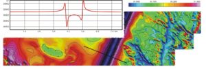
In 2006 I had a job interpreting a series of high-resolution magnetic surveys flown over mineral exploration licenses in Mozambique. It was all fairly straightforward until the data from one block came in, and I thought that I had a banded iron formation to deal with. A closer examination made that look very improbable. Nothing in geology could be that regular, or that simple, and it was Google Earth that supplied the answer. The power-line corridors were just visible, if one looked very, very carefully. On the magnetic maps and profiles one didn’t have to look carefully at all.
There is an interesting back story to all this. The client was in the Middle East, the contractor was in Australia, and the data had gone a long and tortuous way from Mozambique to Wales without anyone en route commenting. Surely the field crew, at the very least, should have noticed, and asked the client what he wanted to do? The power lines should have been listed in the NOTAMS and in any case it was a low-level survey, with a nominal ground clearance of 40m, so they would have been very obvious. Indeed the pilots did give themselves a precautionary 10-20m of height when they went over them. And even if there was no QC man on site, the magnetometer operator would surely have noticed that something was amiss, yet it seems that no-one contacted the client.
Sadly, this was all too predictable, given the circumstances. The client was running out of cash, and payments to contractors and consultants, initially very prompt, were taking longer and longer to get through (eventually they stopped altogether). At the time this particular block was flown, client and contractor were barely on speaking terms, and if they did speak, it was not about the data. So the survey went ahead, just as if nothing untoward was happening!