In late 2022 a book appeared, written by Bill Hinze, with the title From Compass to Drone: The Evolving Role of Magnetics in Mapping the Geology and Ore Deposits of the Lake Superior Region: 1830-2022.
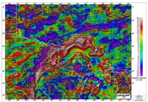
Magnetic map of the Lake Superior Region, from the front cover of Bill Hinze’s book, published in 2022 by the Minnesota Geological Survey.
What this title leads us to expect, and the book provides, is a history of the use of measurements of magnetic field in an area in which they have been of considerable importance in unravelling a very complex geology. It is, however, much more than this. It is also a history, through the medium of an important case study, of the development of the magnetic method in geophysics, and therefore fascinating even to readers to whom the geology itself is completely new. A feature of the book is the attention given to the early days and the early methods. To readers sufficiently long in the tooth, it may be a nostalgic reminder of instruments with which they struggled in their early careers, and of the days before GPS positioning made knowing exactly where you were altogether too easy. It is also a feature that allows the author to introduce some memorable quotes, as on p. 88.
“Magnetic surveys made with the Hotchkiss superdip produced anomalies that defied interpretation.”
Instrumentation may have changed but, as the book makes clear, the problems, which are associated with interpreting a field measured in one direction that is actually a vector combination of a background field in another direction and a local field produced by concentrations of magnetic minerals varying on a local scale and very possibly magnetised in a third direction, have certainly not gone away. The Lake Superior region is widely regarded as the geological type area for the Precambrian banded-iron formations, but it can also justifiably be claimed as a type area for the application of magnetic measurements in geophysical exploration. That application is never simple, even if, as in the subject area, one is looking for iron ore in an area underlain by rocks that are often rich in magnetite. The main iron mineral in the relatively soft ‘direct-shipping’ ores that were the targets of much early exploration was the effectively non-magnetic hematite
The author divides the measurement history into four distinct periods. In the first of these, which he labels the Discovery Years, field workers equipped with rudimentary modifications of the magnetic compasses used for mapping and navigation succeeded in locating and roughly outlining all of the ‘Iron Ranges’ in the Lake Superior region. The name given to these geological units conjures up a vision of highly visible mountains of iron ore, but that does less than justice to the importance of this early work. In many cases the orebodies were poorly exposed and some were completely concealed beneath glacial drift. Today, many of them, far from being topographically high, are marked by very large holes in the ground!
By 1900, the instruments being used, although still based around magnetic needles, had become sufficiently reliable, sufficiently sensitive and sufficiently easy to use to find applications beyond the simple detection of iron ores and to define a new era labelled by the author the Ground Survey Years. Using compasses in their conventional orientation to monitor changes in declination produced data that was extremely difficult to present, let alone interpret, and the crucial advance came with the realisation that the data obtained by flipping the compass upright and effectively measuring vertical field was far more interpretable. Like most good ideas, this one was accepted only reluctantly, in some quarters at least. On p.37 of the book Virgil Hillyer is quoted as claiming that:
…“The dial compass is a more valuable instrument than the dip needle, for in addition to taking magnetic observations with it, an accurate closed survey may be made regardless of local attractions. The dip needle is principally used now [1904] as a check and also to emphasize the results obtained by the dial compass.
Despite this scepticism, it was the vertical force magnetometer, in which the magnetised needle is free to rotate about a horizontal axis, that revolutionised magnetic mapping. During the Ground Survey Yearss, between 1900 and 1940, it became an established geological tool, but in the author’s view this era came to an end with the development of instruments that could be mounted in aircraft. This took mapping to an entirely new level, metaphorically as well as literally, because, although ground surveys continued to be important in detailed work, it became possible to cover large areas very quickly at comparatively low cost. During the Magnetic Survey Years, from 1940 to 1980, the choice between ground and airborne survey was as likely to be made in the light of mobilisation/demobilisation costs as actual survey costs and results. Instrumentation was continually improved and sensitivities were enhanced, to the extent that in the early days of the High-Resolution Survey Years, the era in which we are now living and working, magnetic instrument technology outpaced navigation technology. Improving sensitivity seemed almost pointless when flight-path recovery was still based on matching the survey aircrafts strip film to aerial photography of legacy vintage. That all changed when, on the 1st of May, 2000, Bill Clinton signed the directive making GPS navigation available to civilian users to the same precision as to the military. The stage was set for an explosive growth in magnetic mapping.
For any author of such a comprehensive work, there is an additional complication. Once magnetic surveys began to be used for geological mapping, state boundaries and, even more, the US-Canada boundary, became significant, not to the extent that national boundaries do on other continents (apart from Australia), but significant enough to require, in all except the Discovery Years, separate sections for Michigan, Wisconsin, Minnesota and Ontario. To judge from these sections, these political boundaries are still obstacles to a full understanding of the geological province as a whole.
The book ends with a summary of what had gone before, but it is in his Introduction that the author lays out his shop window. He wrote:
The treatment of the magnetic method and its history that is discussed herein is aimed at the Lake Superior geologist with a basic knowledge of geophysics and geophysicists that are interested in the history of the use of the magnetic method in the Lake Superior region and have limited experience in using the magnetic method in Precambrian shield regions. The treatise will also be of interest to historians of the region especially those interested in the developmental history of the natural resources of the region.
That is much too modest a claim. The book is, or should be, of interest to anyone involved in exploration in Precambrian terrains anywhere in the world. More widely still, every exploration geophysicist should read it, and every student thinking of entering the profession should be pointed in its direction.