The presence of ultramafic rocks on the eastern Indonesian islands of Ambon and Seram has been known since the work of the early Dutch geologists in the East Indies. I am myself the happy owner of one of their remarkably detailed and accurate maps of Ambon, which records the presence of rocks of this type. Inevitably, once the term ‘ophiolite’ came into common use for mafic-ultramafic assemblages where they were found on land, almost all such exposures came to be classed as ophiolitic, but their origin remained controversial.
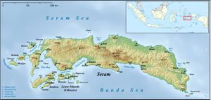
Figure 1. Seram, Ambon and the surrounding islands. Map downloaded from Wikimedia Commons
Then came plate tectonics and, eventually, a consensus that the ‘big slab’ ophiolites found in places such as Cyprus, Oman and eastern Papua New Guinea are segments of forearc emplaced on continental margins during arc-continent collision. This ‘obduction model’ was then applied to less impressive outcrops, until the point was reached at which almost every on-land exposure of mafic or ultramafic rock was taken as evidence for the former existence of an ocean. Doubts were expressed about the universality of the idea, with persuasive arguments being presented for some large ultramafic bodies, such as the Ronda peridotite, being examples of sub-continental mantle, but, almost inevitably, the Seram-Ambon exposures came to be generally viewed in terms of obduction. In 2003, Cristophe Monnier and his colleagues presented a paper in the Bulletin of the Geological Society of France entitled “Dynamics and age of formation of the Seram-Ambon ophiolites (Central Indonesia)” in which this concept was endorsed and applied.
Onle a few years passed before this interpretation began to be seriously questioned. The exposed peridotites (mainly spinel lherzolites) were shown to be associated with rocks that had been metamorphosed at high pressure (corresponding to depths in excess of 30 km) and ultra-high temperature, and were then interpreted as belonging to a migmatitic-ultramafic core complex exhumed by extension along low-angle detachment faults. Two areas were crucial to this interpretation, these being the inland Kobipoto Mountains of central Seram and the more accessible Kaibobo Peninsula in Piru Bay, but these were far from being the only areas where such rocks were to be found.
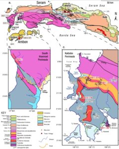
Figure 2. Geology of Seram, with detail of selected areas of western Seram. Figure 2 of Pownall, J. M. et al. 2017. Tectonometamorphic evolution of Seram and Ambon, eastern Indonesia: Insights from 40Ar/39Ar geochronology, Gondwana Research, 44, 35–53
During the next few years models of the processes by which the sub-continental lithospheric mantle had reached the surface were further developed and refined. In later models, the continental lithosphere of Seram, having been drastically attenuated by extension associated with the development of the Banda Sea, was then disrupted by large scale left-lateral transcurrent faulting.. The model was illustrated schematiclly in publications by Powell and his colleagues which extend the interpretation down to depths of almost 100 kilometres (Figure 3).
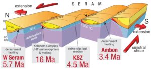
Figure 3. Schematic N-S section across Seram and Ambon showing emplacement of the Kobipoto Complex. SCLM = Sub-continental lithospheric mantle. Figure 14 of Pownall, J. M. et al. 2017.
A natural question to ask is whether geophysical data can add anything to this picture, and whether, in fact, any such data exist.
In 2012 the Indonesian state’s Center for Geological Survey (CGS, the successor to the old GRDC) commissioned a detailed aeromagnetic survey of Seram, Buru and the adjacent seas and smaller islands. In 2016 Siagian et al. published a small-scale version of the resulting map (Figure 4), but their interpretation was centred around petroleum prospectivity and the areas of outcrop of crystalline rocks received little attention. The map emphasises the differences between eastern and western Seram that are very evident in the mapped geology but far less so in the topography (Figure 1), and also suggests a somewhat different trajectory and role for the Kawa shear zone than that shown in Figure 2a. In the western part of the island the zone is marked by a narrow, smoothly northwards convex, belt of anomalies (‘3’ on Figure 4) that are presumably associated with the partially serpentinised peridotites that have been mapped within it. Nowhere does this belt have the partly south-facing convexity shown in Figure 2, and it appears to terminate in north-west corner of Taluti Bay rather than continuing along the north shore. The eastern segment, from the north-east corner of Taluti Bay eastwards, is associated with a much weaker line of magnetic anomaly which also displays north-facing convexity, and which could be a separate structure.
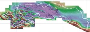
Figure 4. The reduced-to-pole magnetic field of Seram and Ambon.1: Kelang Island. 2: Kaibobo Peninsula. 3: Kawa shear zone. 4: Kobipoto Mountains. Image extracted and modified from Figure 1 of Siagian et al., 2016, High Resolution Magnetic Anomaly Modelling and its Implication for Petroleum Prospectively on Seram Island, Maluku, Indonesia. ASEG Extended Abstracts 2016:1, 1-4.
Strong magnetic anomalies on Seram and its offshore islands are generally confined to the region south of the Kawa Shear Zone, but there is one exception to this rule, in the form of a very concentrated and somewhat isolated region of strong magnetic activity the coincides with the Kobipoto Mountains of central Seram (‘4’ on Figure 4.. The mountain block has been interpreted by Pownall and his colleagues as a pop-up structure related to an east-block-north step in a an east-west strike-slip fault system that has brought Kobipoto Complex rocks to the surface in a series of thrust slices. The dominant direction in the magnetic anomalies is SE-NW, which is consistent with the step direction, but there is no evidence visible on the magnetic map for the controlling E-W structures. One comment that might be made in the light of the magnetic patterns is that it may have been unwise to apply the Kobipoto Complex name also to the far more accessible outcrops of similar rocks on the Kaibobo Peninsula in Piru Bay (‘2’ on Figure 4). Not only does this create a certain amount of uncertainty in the mind of the reader but, despite their geological similarities, the magnetic environments of the two areas are clearly very different. Whatever the historical background to the nomenclature, it is surely not desirable that what is, by default, the type location, should be so markedly atypical.
Frustratingly, the map shown in Figure 4 is the highest resolution version currently publicly available, and this sets strict limits to possible interpretation. The magnetic field is not, however, the only natural potential field with applications to geology. In the northern Banda Arc gravity measurements provide additional, and intriguing, information.
But that is another story.